Sunnyside Loop
 The Sunnyside neighborhood is one of the four neighborhoods that collectively make up the area that most refer to generically as “The Highlands.” The others are Highland, West Highland, and Berkeley. Bounded by Federal Blvd, 38th Ave, I-25 and I-70, Sunnyside has yet to be overrun by hipsters, espresso shops, and micro-breweries. It took me a while to figure out how to get easily to 46th Ave, which ranks in my personal top ten as one of the best east-west streets in Denver, right up there with Dartmouth Ave, Montview Blvd, and 26th Ave. (Aside: have you ever noticed that there are far more great east-west streets in metro Denver than north-south?) Then I discovered a short piece of trail near an abandoned factory out past Cuernavaca Park that provided the missing link and avoided a scary underpass on 38th Ave and multiple twists and turns along Central Ave. The Sunnyside Loop takes in a good chunk of 46th Ave, the Cottonwoods section of Clear Creek Trail, a short stretch of residential climbing hear the Rolling Rock Golf Course, and returns along 20th Ave. You can ride it in either direction. I like going west on 26th Ave and east on 20th Ave, but everyone has a different idea on which is better.The description below starts at Confluence Park and goes counter-clockwise.
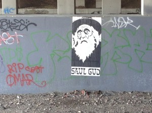
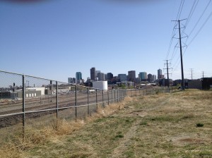
Start at Confluence Park. Get out to Platte St by leaving the Platte Trail at 15th, 16th, or 19th Streets. Ride north on Platte St to where it dead ends in a circle at Cuernavaca Park. This last stretch of road is called Rockmont Drive and honors the now defunct Rockmont Envelope Company that still graces the site, awaiting the right developer and a recovering economy for further direction. Ride north on the trail spur to connect to 37th Ave and Inca St. Some good graffiti and an interesting view of Denver will greet you.
Snake your way along Inca St and 37th ave to reach Lipan St and cross 38th Ave to reach 46th Ave. Ride west on 46th Ave to Tennyson St then go north (right) past Willis Case Golf Course to 52nd Ave, the northern boundary of Denver proper. Jog right and left to stay on Tennyson and descend a fast hill to intersect the Clear Creek Trail. It is not well marked but look for the pedestrian crossing sign and stop if you see the water in the creek.
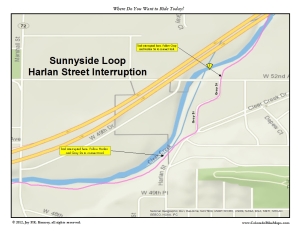
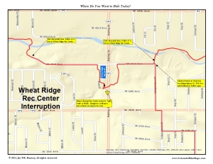
East of here Clear Creek Trail is pretty industrial, but the stretch between Tennyson and McIntyre streets is more natural with good shade on hot days and interesting parks and bridges to hold your interest. Route finding is generally easy–look for the Clear Creek Trail signs and follow them. Sometimes around the many parks along the way there are two possible routes–just follow the trail of least resistance and you’ll be fine. if there’s been a lot of rain, avoid the underpasses along the major roads. Don’t be stupid or careless. If you are caught in a downpour and Clear Creek floods, move to higher ground–don’t seek shelter in one of the underpasses. The trail is interrupted twice, once at 52nd Ave and once again near Kipling St and the Wheatridge Recreation Center. The first interruption takes you briefly along quiet city streets.
The second detours under Kipling and through the Rec Center parking lot. If the Kipling underpass is flooded (it collects water easily) cross (without a light) at 41st Ave or at Kline St (with a light–just south of the Rec Center).
Watch for two sharp sequential humps along the trail, ridges really, that could throw the unwary cyclist. You can also shorten this loop by exiting the trail just before Kipling St at Independence St and riding south to connect to 32nd Ave. Surprisingly, all you need to do is follow the signs.
Exit the trail at McIntyre St by leaving the trail before Mcintyre and ride west on the Frontage Rd to make the turn on McIntyre. How will you know? Look for this building on your left. And if you pass under McIntyre by mistake, don’t worry. Just reverse course on the ramp and enter McIntyre from the west side–it is just an awkward maneuver and the exit from the Frontage Rd makes it simple and seamless.
Ride south on McIntyre to 32nd Ave. Go east (left) a short distance to Kendrick St (look for the sign for the Rolling Hills Golf Course) and escape 32nd Ave by riding south (right) on Kendrick to Fooothills Rd. Turn east (left) on Foothills. Climb through a small residential area and work your way east to Eldridge St. Go south (right) to join 20th Ave.
 2oth Avenue is a great route east back into Denver. Watch out for a narrow area through Lena Gulch (where the Maple Grove Reservoir starts). Otherwise, there is a striped bike lane for most of the return. Just before Sheridan Blvd, detour around Sloan’s Lake at Depew St. Ride south t0 17th Ave, then east again to Sports Authority Mile High Stadium. You’re almost home. Circle the sports complex to the north or south and rejoin the Platte Trail just east of the Stadium. Ride the trail north (left) back to Confluence Park.
-
Archives
- October 2017 (2)
- August 2016 (1)
- July 2016 (1)
- March 2016 (5)
- May 2015 (2)
- April 2015 (1)
- July 2014 (2)
- November 2013 (1)
- May 2013 (3)
- July 2012 (6)
- May 2012 (11)
- April 2012 (2)
-
Categories
-
RSS
Entries RSS
Comments RSS


