Meridian-Inverness Loop
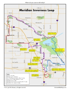
 As much as I like riding in the Front Range foothills and Colorado mountains, there are days when I’m too beat or don’t have enough time to drive anywhere, yet still want a long, quality ride. It’s not impossible, you just have to work a bit. The Meridian Inverness Loop perfectly fits the bill. A similar but shorter loop, “Dove Valley,” was featured in Great Road Rides Denver. At 46 miles, the MI Loop is just as good for a leisurely ride as it is for a weekend hammerfest, with a one lap crit thrown in for good measure at Meridian. If you don’t know your local history, both Inverness and Meridian are business parks built around golf courses, which makes them perfect places for cyclists after work and on the weekends. And if you don’t want to be bothered with the ride to get out there, there are Light Rail stops at both Dry Creek and County Line Roads that provide easy access to the good stuff. This is a good weekend ride, when business and commuting traffic is at its lowest. But during the week, the business park roads get busy and you’ll want to be riding with a heads up attitude.
Begin in central Denver. Head south through Washington Park and jog west to Clarkson and south to Quincy Ave. Go east almost 3.5 miles along Quincy Ave through Cherry Hills Village. This is a good stretch of riding, with a long uphill pull from University Blvd to Happy Canyon Rd. If the traffic is heavy, there’s an OK (if sometimes thorny) path to the south you can use. At Happy Canyon head southeast then south to Monaco St, which in turns connects you to Union Blvd, your ticket through the Denver Tech Center. Climb out of the Tech Center, pass Cherry Creek High School and head south at the Dam Rd light to Dayton Street. Stay on Dayton heading south to Orchard Rd. Go left here to reach Havana St, then south to cross Arapahoe Road. One of my Great Road Rides correspondents hates the intersection of Havana and Arapahoe Rd for all the heavy traffic, but I won’t have a better solution until there’s a bike lane all the way south on Dayton. So for now, at least, cross Arapahoe carefully, then get off it immediately after the light with a left (west) on Costilla Ave. The fun begins.
Work your way south and west along Costilla and Fulton Street, then use Clinton St to cross Dry Creek Rd. Work your way south on Inverness Dr W and Inverness Parkway to reach Valley Highway, which is the link between Inverness and Meridian. Use this detailed map if you find the constant road name changes confusing.  And don’t sweat the name: Valley Highway is not a highway at all–presumably it is just to honor the historic name for for the first portion of I-25 through central Denver to be completed (1950). Pass under E-470. Follow Valley Hwy in a long S-turn to connect, via Jamaica St, with Meridian Blvd. Make a lap or two. There are only two stop lights to slow you down. When you’re ready, exit Meridian and return the way you came along Jamaica and Valley. Bear right after E-470 on Liberty Blvd to connect to Inverness Dr S, which will take you along the southeast side of the Inverness development and then connect to Inverness Dr E. You’ll know you are on the right path if you can look to the right and see the west side of Centenntial Airport–the jets taking off and landing should be a good landmark. Skirt the airport on the north and east using Easter Ave and Peoria St. You’ll know to turn when you see a giant white bubble to the north. Cruise south on Peoria and the east along Bronco Pkwy,
  where new road construction has added a dedicated and sometimes welcome bike lane. A few good rollers bring you to Jordan Rd. Go left for now. Although the Cherry Creek Trail is just east of the Jordan Rd and Bronco Pkwy junction, there’s still a link missing at Arapahoe Rd. After crossing Arapahoe Rd, you can either ride a short stretch of dirt road to enter Cherry Creek State Park, or follow the signs east on Caley Ave to connect to Cherry Creek Trail. Follow Jordan Rd or the trail to the main Park Rd. Use it to circle the east side of the Park.
  Exit the park at the east end of the Cherry Creek Dam Rd, using caution at the intersection. Follow the Cherry Creek Trail back to Denver. you’ll fly home–it’s slightly downhill the whole way.
1 Comment »
Leave a comment
-
Archives
- October 2017 (2)
- August 2016 (1)
- July 2016 (1)
- March 2016 (5)
- May 2015 (2)
- April 2015 (1)
- July 2014 (2)
- November 2013 (1)
- May 2013 (3)
- July 2012 (6)
- May 2012 (11)
- April 2012 (2)
-
Categories
-
RSS
Entries RSS
Comments RSS
[…] east, this great loop complements similar routes in the other sectors of the city: Red Rocks Loop, Meridian-Inverness Loop, and Going to the Dogs […]
Pingback by Table Mountain Loop « coloradobikemaps | April 12, 2012 |