End of the Road Loop
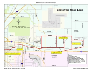
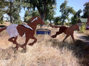
 As summer and fall give way to winter’s cold breath, it is time to start thinking about where you can ride when the days are short and the light comes in steeply slanted from the south. High Grade and most of the foothill rides are probably not great choices. It is cold in the depths of the canyons and the grit and sand that gives traction to cars in the winter plays havoc with our skinny tires. I got interested in the plains east of the city when I mapped the State Time Trial Championship route this year and discovered how much good riding there is east of DIA, out towards Bennett and Watkins. A chance post on 303cycling.com talked about the quiet, interesting roads north and east of Smith Road, way out past the County Jail, I-225, and even C-470. So thanks to Doug for opening up this whole new area to me. As mapped, this route starts at City Park in Denver and then makes a big loop out to and past Watkins. For those days when you don’t want to bite off quite that much, start out near the Sand Creek Greenway at Star K Ranch Morrison Nature Center.
  There’s convenient parking, shady trees, and toilets.
If you start in Denver, navigate out to Smith Road. Ride east on Montview to Yosemite St/Central Park Blvd. Go north, then east along Akron St and 22nd Ave to reach Beeler and 26th Ave. Further east you’ll deadend into Iola St which connects to Havana and then to Smith Rd. This map will show you the way if it’s your first time riding through Stapleton. You’ll know you’re in the right place when you pass the Denver County Jail and the state Diagnostic and Reception Center. The stretch of Smith Rd between Havana and Chambers Rd can feel busy–there are plenty of trucks and not much in the way of a shoulder. But things get better the further east you go. If you are coming from the south, Sable Blvd provides good access almost from the Cherry Creek Reservoir. The fun begins when you leave Smith Rd at Picadilly Rd. Go north then east to 26th Ave. Pretty quickly you’ll get the feel for the riding: lots of empty spaces with corn fields, sunflowers, large industrial operations,
  and a giant solar operation in the middle of a field.
Go as as far east you want or have time for. A few options are laid out in the map, but know that this is just the tip of the iceberg. Go south at Hudson Rd and loop around through Watkins on Colfax Ave. There’s an exit from I-70 here and a truck stop if you need something, and plenty of evidence of hard times and failed dreams. 

If you have a tolerance for somewtimes rough roads, keep going east to Manila Rd before turning north. Otherwise, turn north at Cavanaugh Rd and make your way towards Front Range Airport, DIA’s general aviation little brother. If you don’t make it to Manila Rd, do an out and back on 48th Ave, just for the sheer joy of riding along on a nearly deserted road on the edge of the historic short grass prairie. 
To return from Front Range Airport, work your way north on Imboden Rd to 56th Ave and then turn west. It is hard not to be impressed and overwhelmed by the sheer immensity of all that stretches before you: acres of sunflowers, fallow farmland, the hustle and bustle of aircraft taking off in short steep arcs and landing in long shallow ones, and in the far distance the Rocky Mountains, beckoning you home again. 
Ride west. Depending on your mood or time of day, use Hudson, Monaghan or Picadilly Rd to drop back down to 26th Ave and Smith Road. Return to your starting place.
-
Archives
- October 2017 (2)
- August 2016 (1)
- July 2016 (1)
- March 2016 (5)
- May 2015 (2)
- April 2015 (1)
- July 2014 (2)
- November 2013 (1)
- May 2013 (3)
- July 2012 (6)
- May 2012 (11)
- April 2012 (2)
-
Categories
-
RSS
Entries RSS
Comments RSS