Buffalo Bicycle Classic


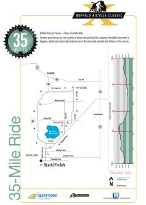

If you’ve ever wanted to ride up Boulder Canyon without a car breathing down your neck, you can do it in the Buffalo Bicycle Classic. Now in its eleventh year, the BBC raises scholarship money for the College of Arts and Sciences at CU Boulder. This year’s long course again rides up Boulder Canyon, traverses the Peak to Peak Highway, and descends St. Vrain Canyon to Lyons. Instead of turning south immediately, however, the long course runs up north for a 30 mile loop around Carter Lake–a big improvement over last year’s long course. On the return it passes through the well-traveled and bucolic roads of eastern Boulder County. Other shorter options are also available. Happily, the BBC has raised more than $1.6 million in scholarships for promising students and (sadly) is the single largest source of scholarships within the College. September 8, 2013. Don’t miss out. The 2012 routes are shown below.


Venus de Miles

The century season comes to a close in Colorado in late August and early September. Two rides round out the season, Venus de Miles and the Buffalo Bicycle Classic. Both are true fundraisers, the one for Greenhouse Scholars, the other for the University of Colorado College of Arts and Sciences. Venus is open only to women. The Buff is open to all. The Venus date is Sunday, September 29, and it starts and finishes in Longmont, with many options for all riders. Fees for Venus are low, approximately $90, but each participant must also donate or raise $75 for Greenhouse Scholars, so the price is comparable to other Colorado centuries. The course promises an interesting tour of eastern Boulder County farmlands with great views of foothills and mountains to the west. The 2012 century map is shown below.

Boulder Roubaix
[The original of this post somehow got deleted, so this replaces that posting from early March.]
 Singletrack Maps makes beautiful maps for mountain bikers in the Crested Butte, Durango, Ft Collins, Lyons, Golden, and Buffalo Creek areas. They also make race maps for DBC Events, which organizes and promotes, among others, Boulder Roubaix, Mead Roubaix, and the new Candela’s Circuit Race. If you’ve never ridden a Roubaix style race, or are interested in a classic gravel grinder or even something more extreme, like the rides in the Colorado Endurance Series, this is a great place to start. The 18 mile loop takes in the best parts of northeast Boulder back roads, with a particularly stunning stretch along Crane Holllow Rd. If you don’t live in the Boulder area, this is a good introduction to the mix of gravel and paved roads that make up the the cycling grid in Boulder County and that make the County such a great place to be a cyclist.You’re not likely to be alone up here–all these roads are well-traveled by many cyclists, joggers and walkers.
If you are not racing, start this one anywhere. You can ride out from Boulder, park along most of the roads, or find a convenient parking area such as that just west of 39th Street and Neva Rd. There are not a lot of C-stores out here, so it can be handy to pass near your car every loop you make. The loop shown is a an almost even mix of dirt and pavement, with most of the dirt well compacted by the use of magnesium chloride. Ruts, loose gravel, and narrow roads make this an interesting ride. There’s a very detailed description, from a racer’s point of view, of the dirt sections in Russell Harding’s blog, the Road to Cat 1.
Flagstaff-Gross Reservoir Climb
 If you lived in Boulder, this would be your daily short climb, your testing ground, your climb against which to measure your fitness from month to month and year to year. Robert Hurst, in Road Biking Colorado’s Front Range, calls it Boulder’s little Alpe d-Huez. He’s exactly right. Every town has one. In Golden, it’s Lookout Mountain. In Fort Collins, it’s Rist Canyon, in Aspen it is Maroon Bells, in Colorado Springs it’s probably North Cheyenne Canyon. If you live in one of those towns, I always wonder if you ever go anywhere else. I mean, why would you, when you have [fill in the blank] in your backyard. It is like having a condo in Vail, Aspen, or Frisco. Inertia sets in. Why would you ever go anywhere else? But for the rest of us in the altitude deprived plains, we have no choice but to pack up and make a pilgrimage (or multiple ones) to the shrines and mythical places we only hear about in whispered (well, sometimes bragging) tones around the odd beer or espresso. I’m pretty sure we all believe that our local climb (or our last steep climb) is as hard as anything else out there. But wherever you live and whatever your ego, put it all aside and get up to Boulder sometime before the snow flies and ride on out to Gross Reservoir
and back. You won’t regret it.
For out-of-towners, there’s usually good parking at Chautauqua Park, but if that fails, you are far enough west to park in the neighborhood without running afoul of Boulder’s sometimes draconian parking regulations. If you go past the Gregory Canyon trailhead, you’ll be inside the park system and be required to pay a fee (unless you have local plates). Saddle up. Start climbing. Once you pass the Gregory Canyon trailhead, hard climbing starts immediately with a short stretch averaging 10%. If you want lots of detailed climbing information beyond what’s provided above and below, check out Russell Harding’s blog, The Road to Cat 1, or the 303cycling.com website. But if you want to preserve some mystery, just know that it starts out hard, eases up, then finishes, after the turnoff to the Amphitheater, with a stretch of ridiculously hard climbing. The pain is blessedly short. And if you want to see how you measure up against the best, time yourself from the stone bridge at Gregory Canyon to the Amphitheater Rd turnoff (11:59, Scot Eliot), or to the mailboxes near Bison Dr (22:10, Tom Danielson).
If you are new to Boulder or foothills riding in general, know that the views are amazing (if you can look up long enough to enjoy them) and there are several easy pullouts along the way where you can stop, catch your breath and admire the view. You should also detour at least once out along Amphitheater Rd. Many turn around here and avoid the final climb. Finally, recognize that you’re not likely to be alone on this stretch of road and check your ego accordingly. You’ll share it with cars, motorcycles, hikers, boulderers, wildlife, and other cyclists. The shoulder comes and goes and where it exists, it is biased in favor of uphill traffic, a striping scheme that makes sense when you think about it.
After you pass Bison Road, keep going and you’ll have most of the road to yourself. You’ll level out briefly as you pass Kossler Lake, 
but then the road plunges sharply down for two miles into an area partially burned by the Walker Ranch/Eldorado fire of 2000. 
One more short (steep!) climb will bring you to a picnic area overlooking the reservoir that provides a convenient place to water up and eat a snack. After what you’ve been through, the climb back up to Kossler Lake is pretty straightforward. 
SIf you are still hankering for adventure, check out Robert Hurst’s book. He’s got a challenging, 33 mile loop sketched out that takes you over dirt to Coal Creek Canyon and then loops around back to Boulder on 93. It is definitely not for the timid or those challenged by dirt roads.

-
Archives
- October 2017 (2)
- August 2016 (1)
- July 2016 (1)
- March 2016 (5)
- May 2015 (2)
- April 2015 (1)
- July 2014 (2)
- November 2013 (1)
- May 2013 (3)
- July 2012 (6)
- May 2012 (11)
- April 2012 (2)
-
Categories
-
RSS
Entries RSS
Comments RSS
