Welcome!
Welcome to ColoradoBikeMaps, the blog to discover all the places and ways you can ride a bike in Colorado. The blog focuses on route maps along the front range, but include maps from all over Colorado as time and inclination dictate. The blog is an outgrowth of my book, Great Road Rides Denver, published in 2010 by Fulcrum Books and still available in the Denver metro area, including The Bicycle Dr on Broadway and 9th Ave, AKA Evo.com, Tattered Cover, and Amazon. Variants of some of the 25 routes found in GRRD appear in the blog, but without the detailed route information that only a guide book can provide. While GRRD focuses on rides within and around metro Denver, ColoradoBikeMaps includes many of the rides in the foothills between Deer Creek Canyon and Golden Gate Canyon, just north of Denver. I’ve also added race maps that I’ve made for the USA Cycling chapter here in Colorado (Coloradocycling.org) as well as from other cartographers and promoters. There are also links and maps to many of the organized charity rides that you can find from June to September in Colorado. Even when the ride is no longer promoted, I’ve kept the maps. They are still interesting routes to ride. There are also a couple of routes from John Hodge in Grand Junction, a similar, cycling obsessed, cartographer.
Most of the work of the past few years has been on a major map of the cycling trails along the metro front range, one that shows all the region’s major trail systems and how to link them up. You can see a preview of the main map below and can buy your own copy at Tattered Cover Bookstore (all three stores), Turin Bicycles and Bicycle Doctor + Evo (both Denver), and Golden Bike Shop and Big Ring Cyclery (both Golden). An app from Avenza Maps incorporates the entire 36″ x 24″ map and allows easy navigation while on your bicycle.
Disclaimer: Cycling can be dangerous if you crash. It can also be dangerous if you are hit by another cyclist, a car, a train, or a meteor. In all cases, I disclaim responsibility for all bad things that happen to you when you are out on your bicycle (but do not wish them on you). I’ve made these maps from sources that are usually reliable, but GIS data, roads, trails, and routes all change. If you discover a mistake in a map, let me know, and I’ll correct it. Good decision making and sound judgment are the responsibility of the individual. We assume no liability from injury that may result from the use of these maps.
Jay[@]ColoradoBikeMaps.com
Update–Little Dry Creek Open (Sort Of)
Well, finally. Another of the 5 or 6 people who follow this blog wrote last week to say that Little Dry Creek at Federal Blvd has been reopened after months and months of work on RTD’s G-Line, itself an exercise in delays and patience. The G-Line will run between Union Station and Arvada and Wheat Ridge but has been delayed by sticky software that makes the crossing gates unpredictable. At least the trail is now completely open and it’s possible to ride to Boulder on the US 36 Bikeway without a lot of machinations.


What’s missing are the all important signs to tell you when to leave the Little Dry Creek drainage to connect to the US 36 Bikeway. I rode up there to check it out this past weekend and found many signs pointing to religion and possibly salvation, but none that said “Boulder, this way.”

Here’s the way it works (from Denver): Look for England Park and exit the trail there, onto Raleigh St. You’ll know you’re in the right general vicinity when you pass the dog park and see a baseball field, both on your left. Exit left onto Raleigh and ride to 72nd Ave. Go right, then immediately left to Bradburn and you’re home free. From a map perspective it looks thus:

You’ll know you’re in the right spot when you see the sign for the various churches. Enjoy the ride and thanks to Ken for the pictures and the information.
Work began in 2019 between Federal and Pecos on Little Dry Creek Trail. It was closed in September with no signage to say when it would re-open. Updates from readers always welcome.
Important Update: Chatfield Reservoir
One of the 5 or 6 readers of this blog recently wrote in to tell me that it’s impossible to ride from the end of the Highline Canal Trail through Chatfield to rejoin the road and make a nice loop ride back up the Platte River Trail. What I’ve said here and in last year’s map is that you can dodge the traffic on Santa Fe/US 85 (it’s an unprotected crossing), hike your bike across the railroad tracks (probably illegal), and ride or walk down a sketchy trail to hook up with a paved trail within the park. When I last did (May, 2016) it was a mess, as evidenced by this IG shot I took:
I assumed at the time this was just bad luck on my part. There had been rain, lots of run-off, and I like a little dirt and gravel on my rides, so I just chalked it up to bad timing.
Turns out we have beavers to thank for the watery mess.

As Andrew put it: “[I] discovered the trail in this part of the park is currently impassible due to flooding. I spoke with another cyclist who said it has been this way for about a year and is caused by a beaver dam on Plum Creek, which the park has been reticent to damage (understandably). There are no good alternatives to complete the loop — High Line ends at private land before getting a rider to Titan Pkway.”

I hope I’m not the only one to see a rich irony in the work of the mighty Army Corps of Engineers laid low by the humble beaver. So unless and until they move on, ride the rough gravel trail along the top of the dam to connect up to the Highline Canal. And thanks, Andrew, for letting us know.
Another reader says: “Chatfield State Park is under construction due to raising the water level 12′, which is really a lot measured horizontally. All roads and bike paths on the south end are closed. This state park is good about recreation, and the bike paths are intended to re-open April 1, 2019. However, if you go on a weekend, the path from the High Line down to Plum Creek is in perfect condition – the lower section is new concrete with 3 new bridges. Still have to hike-a-bike up the embankment to the railroad tracks, but the continuation of the High Line is right there.”
Major Metro Trails

I am happy to announce the publication of my new bicycle map for the Denver Metro Region. With more than 600 miles of trails, 40 distinct trail systems, it’s color-coded so you can see if you’ll be on a paved surface (red), a dirt trail (brown) or a bike-friendly surface street (blue) to link different trail systems up. The front side is the metro region (Superior to Parker, Commerce City to Chatfield Reservoir) and the reverse side has 6 detailed maps of places you’ll want to ride, including the four main reservoirs (Chatfield, Cherry Creek, Aurora, and Bear Creek), the south end of the Cherry Creek Trail, and Horseshoe Park in Aurora. Waterproof and tear proof. Get ’em while they’re (and it’s still) hot, $12.95. Find it at Tattered Cover (all three stores), Evo-Edgeworks, Turin Bikes, Big Ring Cycles, and the Golden Bike Shop. The QR code on the map links you to a digital version you can use with your smartphone and the map app from Anveza Maps, $5.99. Happy Trails to all.
US 36 Bikeway + Little Dry Creek Trail Update

Several people have asked me about riding to Boulder via the newly-opened US 36 Bikeway and over the past weekend I finally had time to check out the construction on the new commuter rail line that’s been creating havoc along Little Dry Creek and Clear Creek Trails for the past 2 years. What I discovered was both promising and disappointing. The good news first. The Northwest Rail B-Line is nearly complete and is scheduled to open on July 26, 2016. When all the work is complete, there will be a newly reconstructed trail along Little Dry Creek between 64th Ave and Lowell Blvd and near the intersection of 72nd Ave and Braeburn Blvd which is the north-south access between Little Dry Creek and the beginning of the US 36 bikeway. There is also going to be a new spur south of Clear Creek Trail which will take cyclists to the Federal Blvd station of the Gold Line.
The bad news: (1) the work to date on Little Dry Creek has created several hazardous underpasses that will regularly flood and for which there is no easy by-pass above the grade of the creek. When these are not flooded, they will require constant maintenance to sweep out the mud and sand that accumulates after every rain storm, and judging by current conditions, Adams County is not up to the task. (2) Even with the scheduled opening of of the B-Line, it sure does not look as if the trail between 64th and Lowell Blvd is going to open very soon. There is a lot of landscaping work still to be done between Federal and Lowell and there is also a large CDOT project reconstructing the bridge over Little Dry Creek at Federal Blvd. (3) The detour signing along the closed portions of Little Dry Creek is non-existent or inadequate. From the southeast, there are no signs indicating the trail is closed until you run smack into a concrete barrier north of 64th Ave. From the northwest there are the beginnings of a posted detour, but they led me astray, routing me south along Lowell Blvd without ever turning me east back towards Little Dry Creek. I cannot do much about (1) or (2), but I did work out a passable detour, along 64th, Irving, and 68th Ave between Lowell Blvd and the start of Little Dry Creek. It works pretty well, save the time you have to ride along 64th Ave which carries significant truck traffic. There’s also a sketcher version I checked out from Little Dry Creek Trail after the second underpass. It routes you along a dirt and gravel road to 68th Ave, then north and west across Federal to Lowell Blvd. It’s doable, but not for most cyclists.
The photo below is from the Federal Bridge looking northwest, with the new Little Dry Creek Trail beckoning.

This is the unexpected barrier you’ll encounter if you ride along Little Dry Creek expecting to be able to reach the US 36 Bikeway.
 And finally, This shot shows some of the work being completed on thrnew bridge project along Federal Boulvard. That work has just begun and is not expected to be completed until July 2017. Feel free to drop the CDOT communications manager a note asking CDOT to provide and post an adequate detour around the work that CDOT is doing.

Cherry Creek Reservoir
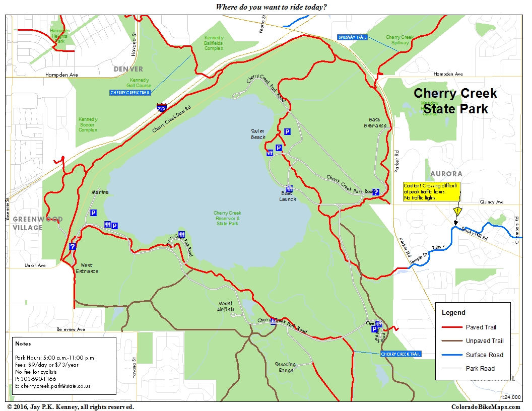
This is a map to supplement the Major Metro Trails Map. It shows the area in and around Cherry Creek Reservoir and State Park, one of the busiest cycling destinations in the region. Go there just to ride around, or ride through it on your way to points south (Cherry Creek Trail), east (Piney Creek), or northeast (Spillway Trail).
Golden + Lakewood Area

This is the second of several maps to supplement the Metro Major Trails Map of 2016. The Golden and Lakewood area has connections to the Clear Creek Trail (northeast), the C-470 Trail (south) and on street access to many of the signature foothill rides, including Golden Gate Canyon, Lookout Mountain, Red Rocks, and the town of Morrison. With the recent opening of the West Rail Line, there is also an excellent, safe alternative to 32nd Ave along the West Rail Line, some on-street, some on dedicated trails.
Chatfield Reservoir Area

Yet another supplemental map. Chatfield Reservoir is a federal flood control project managed as a state park by the Colorado Department of Natural Resources. It features all of the typical amenities you would expect at a large, urban state park and provides excellent cycling in and around the park. There is no way to loop around the park on trails alone, but it is possible to circle the reservoir and most of the park if you don’t mind some dirt and don’t mind walking down a steep section near the southeast corner of the reservoir. The best access is from one of several trails: C-470 (northwest), Cherry Creek Trail (north) and the Centennial Trail (northeast). There is also on street access from Wadsworth Blvd and from the Highlands Ranch Trails to the east. This access requires you to cross Santa Fe Blvd (US 83) and it is an entirely unprotected crossing without lights or pedestrian striping and is not recommended.
Horseshoe Park Area
 This is another of the maps that usefully supplement the recently published Major Metro Trails Map of 2016. The Horseshoe Park area is one of Aurora’s better kept secrets. It provides links to Toll Gate Creek, the Cherry Creek Spillway Trail, and the Powerline Trail, with access in all directions. Signage can be challenging, but this is a great starting place from which to explore trails in all directions.
Cherry Creek Trail South
 This is one of the maps that supplements the recently published Major Metro Trails map. It shows the detail of the Cherry Creek Trail from Centennial south to its unhappy end.

Presumably, there are plans to acquire an easement through the private property to extend the trail onward to Castlewood Canyon State Park.

Fortunately, if you exit the trail before the dead end, at Walker Rd, you can easily ride south on a surface street to the park. There are few navigational difficulties and a couple of interesting detours that are destinations in their own right, the Sulpher Gulch Loop in Parker, and the Pinery Loop. There is one section of dirt that I found to be in tough shape–deep mud, many ruts–there’s a viable work around on the streets between Scott Ave and Bayou Gulch Rd.
Plains Conservation Loop

This one rides better than it reads. In fact the real knock on this route is that it is hard to figure out some times if you are on the right trail segment or not. Mostly, this is a signage problem, as in the City of Aurora is doing a terrible job labeling and signing their trails. It is really that bad and really that simple. But first, a few general thoughts on access and the ride character. I usually ride this clockwise and like heading out 7th Ave east across Colorado Blvd then continuing on 6th Avenue to Uinta St. Sixth Ave is not everyone’s cup of tea so feel free to ride east on 7th Ave instead. This ride takes you way out east, past all of the suburban sprawl, to a point where you can see the plains and nothing beyond them (at least if you look in the right direction). If you look to the northeast from Plains Park, you can also see the giant white bubbles that mark Buckley Air Force Base’s electronic monitoring stations. The dirt trail along the Plains Conservation Center is tricky in a few places but worth the extra effort. There are a few spots to pay attention, especially where the signage is inadeqaute.
Working clockwise, the exit from the High Line Canal to Toll Gate Creek Trail isn’t obvious. You’ll have passed under Chambers Rd, passed by an old historic farm, crossed over the High Line Canal and poof! there it will be. Look left, cross down and under Alameda Ave, and all will be well.
After that you’ll be riding south on Toll Gate. You’ll come into Horseshoe Park and will need to ride east on Powerline Trail. Your clue for when to turn is the power lines themselves. Look for them! They’re big and tall and hard to miss. Keep riding east.
You’ll eventually come to a park with a playground. Work your way around to the west side and you’ll have a choice of a dirt trail or a paved trail. Both are fun. If you ride the dirt, it stops (and you should, too) at Hampden. Ride the sidewalk east to Skills Park, and go north through the park then angle left onto a (you guessed it) No Name Trail. Crazy, isn’t it? No wonder they cannot stick a sign in the ground. If you are riding the paved trail, look for the no name trail angling sharply off to the right. Follow it to West Toll Gate Creek Trail back to Horseshoe Park and from there ride home the way you came or head southwest to Cherry Creek Reservoir. Alternately, there’s a short stretch of West Toll Gate Creek Trail that leads south to Dartmouth Ave if you’re interested in some of Aurora’s finest on-street riding.
If you’ve made it back to Horseshoe Park and want to ride the full loop, all you have to do is figure out how to get out and south the Spillway Trail. It is not easy, but well worth it, if only to try to imagine what kind of cataclysmic event it would take for the spillway to ever come into play. And if you can imagine that, what would Horseshoe Park look like under that much water? The map below probably explains the route and route finding difficulties better than I can, so take a look and give it a try. The neighborhoods just south of Horseshoe are not super busy, so even if you are off route somehow, nothing ugly is going to happen. Once you’re on the Spillway Trail, the only remaining obstacles are the several at-grade crossings just north of the park. Use the crosswalks, be patient, and all will be well.

One final note. I’ve shown this as a kind of open-jawed route with access from the north along 11th Ave to CU Medical School and the Anschutz Medical Plaza and from the south through the reservoir and from Denver along the Cherry Creek Trail. Rding in from northwest Aurora to Southwest Aurora is a tale of two cities (almost). The contrast is stark between the older and seemingly less affluent northwest and the suburban southwest. It is one of those things that makes riding a bicycle so interesting–there’s no screen between you and the world around you.
-
Archives
- October 2017 (2)
- August 2016 (1)
- July 2016 (1)
- March 2016 (5)
- May 2015 (2)
- April 2015 (1)
- July 2014 (2)
- November 2013 (1)
- May 2013 (3)
- July 2012 (6)
- May 2012 (11)
- April 2012 (2)
-
Categories
-
RSS
Entries RSS
Comments RSS
